Land Regions
China can be divided into eight major land regions. Below is information on each one.
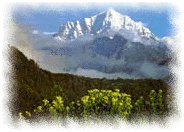 Mount Everest
|
The Tibetan Highlands
This region lies in southwestern China. It consists of a vast plateau bordered by towering mountains - the Himalaya on the south, the Pamirs on the west, and the Kunlun on the north. The world's highest mountain, Mount Everest, rises 29,028 feet (8,848 meters) above sea level in the Himalaya in southern Tibet. Two of the world's longest rivers, the Huang He and Yangtze, begin in the highlands and flow eastward across China to the sea.
Tibet suffers from both drought and extreme cold. Most of the region is a wasteland of rock, gravel, snow, and ice. A few areas provide limited grazing for hardy yaks--woolly oxen that furnish food, clothing, and transportation for the Tibetans. Crops can only be grown in a few lower-lying areas.
The Xinjiang-Mongolian Uplands
The Xinjiang-Mongolian Uplands occupy the vast desert areas of northwestern China. The region has plentiful mineral resources. However, it is thinly populated because of its remoteness and harsh climate.
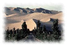 the Gobi Desert
|
The eastern part of the region consists of the Ordos desert and part of the Gobi desert. The western part is divided into two areas by the Tian Shan range, which has peaks over 20,000 feet (6,096 meters) above sea level. South of the mountains lies one of the world's driest deserts, the Taklimakan. The Turpan Depression, an oasis near the northern edge of the Taklimakan, is the lowest point in China, lying 505 feet (154 meters) below sea level. To the north of the Tian Shan, the Dzungarian Basin stretches northward to the Altai Mountains along the Mongolian border.
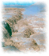 Huang He: the Yellow River
|
The Mongolian Border Uplands
This region lies between the Gobi Desert and the Eastern Lowlands. The Greater Hinggan Mountains form the northern part of the region, where the terrain is rugged, and little agriculture is practiced. The southern part of the region is thickly covered with
loess, a fertile, yellowish soil deposited by the wind that consists of tiny mineral particles and is easily worn away. The Huang He and its tributaries have carved out hills and steep-sided valleys in the soft soil. The name
Huang He means
Yellow River and comes from the large amounts of loess carried by the river.
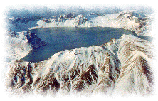 the Changbai Mountains
|
The Eastern Highlands
This area consists of the Shandong Peninsula and eastern Manchuria. The Shandong Peninsula is a hilly region with excellent harbors and rich deposits of coal. The hills of eastern Manchuria have China's best forests, and timber is a major product of the region. The highest hills are the Changbai Mountains (Long White Mountains) along the Korean border. To the north, the Amur River forms the border with Russia. Just south of the river are the Lesser Hingan Hills.
The Eastern Lowlands
The Eastern Lowlands lie between the Mongolian Border Uplands and the Eastern Highlands and extend south to the Southern Uplands. From north to south, the region consists of the Manchurian Plain, the North China Plain, and the valley of the Yangtze River. The Eastern Lowlands have China's best farmland and many of the country's largest cities.
The Manchurian Plain has fertile soils and large deposits of coal and iron ore, and most of Manchuria's people live on the southern part of the plain near the Liao River. To the south lies the wide, flat North China Plain in the valley of the Huang He. Wheat is the main crop in this highly productive agricultural area. Major flooding formerly occurred every few years in the Huang He valley. These frequent and destructive floods earned the river the nickname "China's Sorrow." Today, a system of dams and dikes controls most floods.
 the Yangtze Valley
|
The Yangtze Valley has the best combination of level land, fertile soil, and sufficient rainfall anywhere in China. In the so-called Fertile Triangle between Nanjing, Shanhai, and Hangzhou, the rural population exceeds 5,000 people per square mile (1,900 per square kilometer). The Yangtze River and its many tributaries have long formed China's most important trade route.
The Central Uplands
This region is an area of hills and mountains between the Eastern Lowlands and the Tibetan Highlands. The Qin Ling Mountains are the chief physical feature of the region with peaks that rise more than 12,000 feet (3,658 meters) above sea level near the city of Xian. The Qin Ling cross the region from east to west, forming a natural barricade against seasonal winds that carry rain from the south and dust from the north. For this reason, the Qin Ling Mountains are China's most significant geographic boundary. To the north of the mountains are dry wheat-growing areas, and to the south lie warm, humid areas where rice is the major crop.
 Sichuan
|
The Sichuan Basin
This area lies south of the Central Uplands and is a region of hills and valleys surrounded by high mountains. A mild climate and long growing season make the Sichuan Basin one of China's main agricultural regions. Most crops are grown on
terraced fields - level strips of land cut out of the hillsides. The name
Sichuan means
Four River and refers to the four streams that flow into the Yangtze in the region. The rivers have carved out deep gorges in the red sandstone of the region and so made land travel difficult. Ships can travel on the Yangtze into western Sichuan, but only small craft can navigate the river's swift-flowing tributaries.
The Southern Uplands
The Southern Uplands cover southeastern China, including the island of Hainan. It is a region of green hills and mountains, and the only level area is the delta of the Xi Jiang (West River). The Xi Jiang and its tributaries form the main transportation route for southern China. Guangzhou (also called Canton), southern China's largest city, lies near the mouth of the Xi Jiang. Deep, rich soils and a tropical climate help make the delta area an extremely productive agricultural region.
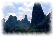 Guilin
|
Much of the Souther Uplands is so hilly and mountainous that little land can be cultivated, even by terracing. The central part of the region, near the city of Guilin, is one of the most beautiful areas in China. It has many isolated limestone hills that rise 100 to 600 feet (30 to 182 meters) almost straight up.


 Chinese Culture