 Chinese Culture
The Land Of China -- Landmarks
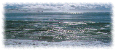
Huang He
The 5,500-kilometer-long Huang He, meaning "the Yellow River", originates from the Kunlun Mountains in western China and flows generally eastward across northern China to the Gulf of Bohai. It is named for the vast quantities of yellow silt it carries to its delta.
The river often causes devastating floods on the plains of its lower course due to elevated river bed. Huang He is also called the "mother river" of China, for the Chinese civilization has evolved in the region around the river. A 50-year construction program, designed to control future flooding and to harness the river for increased irrigation and hydroelectric production, was initiated in 1955.
Setting
|
Huang He is the second longest river in China. Tracing to a source high up the majestic Kunlun Mountains in the nation's far west, it loops north, bends south, and flows east for 5,464 kilometers until it empties into the sea, draining a basin of 745,000 square kilometers which nourishes 120 million people. Millennia ago the Chinese civilization emerged from the central region of this basin.
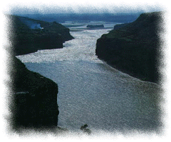
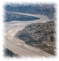
As the most heavily silt-laden river in the world, the Yellow River got its name from the muddiness of its water, which bears a perennial ochre-yellow color. The river is commonly divided into three stages. In the upper reaches, the river runs through mountainous and arid regions for 3,472 kilometers, ending at Hekouzhen of Inner Mongolia just before it makes a sharp turn to the south.
In the middle reaches, ending at Zhengzhou in Henan province, the river flows south between the Shaanxi and Shanxi Provinces, draining a basin consisting largely of thick deposits of unmodified aeolian loess which is eroded readily by rainfall and wind and accounts for over 90 per cent of the sediment in the main channel downstream. After traversing a 1,206-km course from Hekouzhen to Zhengzhou, the river emerges from narrow mountainous constrictions onto a flat alluvial plain shortly following a sharp turn to the east.
|
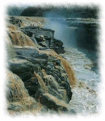
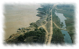
In the lower reaches, from Zhengzhou to the sea for a distance of 786 kilometers, the river is confined to a levee-lined course as it flows northeasternly across the North China plain before emptying into the Gulf of Bohai. During two thousand years of levee construction, excessive sediment deposits have raised the riverbed several meters over the surrounding grounds; it is as much as 10 meters above the city level of the ancient capital Kaifeng on its southern bank, where the levee embankments are 13 kilometers apart. Nearly all rivers to the south of the levee-protected channel drain into the Huai River system, while those to its north into the Hai River system .
Flood devastation has caused untold human suffering throughout the river's history, and the Yellow River has gained the unenviable distinction as "China's Sorrow". Records indicate that the river's levees were breached more than 1,500 times, and its course has changed 26 times in the last three millennia. A major course change taking place in 1194 A.D. was probably the most devastating economically. Flood water rushed onto the Huai River basin south of the Yellow River and took over Huai River's drainage system for the next 700 years.
|
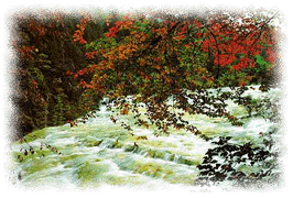
The river's sediment comes entirely from the middle region of the river's basin, draining a loess-covered terrain consisting of a wind-blown silt deposit of high uniformity. Though the climate there is arid with an annual rainfall in the 400-millimeter range and the annual evaporation rate is three to four times as much as in other places, during the July-August-September rain season, rain bursts out which account for almost half of the annual precipitation. Such sudden amounts of rain erode loess cliffs rapidly bringing a huge amount of the eroded silt into the gullies, from which it is funneled into the rivers and to the main channel, transported laboriously for a distance over 1,000 kilometers before it is flushed out to sea.
the Cradle of Chinese Civilization
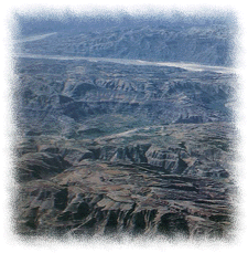
Why is Huang He basin the "Crade of Chinese Civilization"? Some say it has something to do with the terrain in the Yellow River basin, the terrain of the loess plateau. The loess plateau in the Yellow River basin extends for an area of 43,000 square kilometers lying mainly in Shanxi, Shaanxi, Inner Mongolia, and Gansu. For the most part, the loess plateau is badly dissected by gullies due to erosion, and its features are generally referred to as "Qian Shan Wan He" (thousands of hills and ten folds more gullies). Transportation is so prohibitive within such a terrain that it simply cannot facilitate the emergence of a viable society.
|
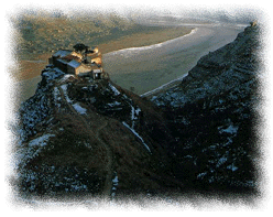
The answer lies in a certain landform called Tai Yuan, a sort of tableland on a plateau, unknown anywhere else on earth. Tai Yuan represents an original state of the loess plateau before it is totally carved up by erosion. There are still several pieces of such Tai Yuans in existence today, mostly in the western part of the Wei River Valley along the border between Shaanxi and Gansu. They are ideal for agricultural production as well as community activities.
A few thousand years ago, the Tai Yuan landform must have been even more extensive and better connected allowing it to faciliate unrestricted transportation. Jingchuan in Gansu is situated by the Jing River with its activities center around the river, 200 meters below the height of a normal Tai Yuan. There is nevertheless a small piece of Tai Yuan at a hill top, a small pile of earth amid a field of corn.
|
The so-called "cradle of Chinese civilization" cuddled people and events much earlier than those of the Three Kingdoms, all the way back to the time of the legendary Yellow Emporor Huang Di, about 4000-5000 years ago. The Banpo Museum outside Xi'an preserved the remains of a sequence of neolithic societies from 6000-9000 years ago. Chinese anthropologists consider them to be matriarchal societies adopting a communal way of life, which was imposed on the inhabitants not by choice but from scarcity. There was barely enough food provision to last from one year to another, and the society was not given the luxuary to operate in any other way but to share equally.
After the early matriarchal societal structure was replaced by the patriarchal structure, rapid rise in agricultural productivity made available food surplus for the first time in the history of mankind.
|
Huang Di came originally from Shandong, and all of the famous tribal battles that he allegedly fought were located in the present North China plain which at the time was part of the Yellow River's flood plain. This shows that the wealth over the plain was abundant. He abandoned such an abundant plain and came to the hilly region of the present-day basinbecause of the landform of the Tai Yuan. The steep slopes on the two sides of a Tai Yuan provided its inhabitants favorable defensive advantages.
Huang Di, after occupying one such favorableTai Yuan site, decided to settle down and abandon the marauder's way of life.
|
With time, walled cities were built and communities no longer relied on the Tai Yuan for protection. Descendants of Huang Di began to move away from the loess plateau to occupy more favorable sites in terms of production and transportation. A population burst occurred as they brought with them their superior political skills which they acquired through several hundred years of uninterrupted practice and gave birth to the most glorious civilization on the face of the earth. The Chinese people are forever grateful for such a gift from Huang Di that call themselves the Descendants of Huang Di.


